It was hoped to have found a description of the Crathes area in the Statistical Account of Scotland. However, because of the more important township of
Banchory-Ternan nearby, Crathes has apparently not been described in detail or isolation. The following is a collection of facts and observations about
Crathes.
Location and topography:
Crathes lies in the Dee valley some 18kms south-west of the city of Aberdeen. Bounded by the River Dee to the south, the Hill of Fare to the north, The Burn
o’ Bennie at Banchory to the west and Drumoak to the east, Crathes is an area of rural land comprising arable agriculture, forest, peat bog and one principal
settlement. Generally the topography rises from the Dee in the south to the base of the Hill of Fare in the north, affording the area a pleasant southerly
aspect.
Climate:
Lying between the Grampian mountains and the sea, Crathes neither suffers from the temperature extremes of the hills nor the wind and fog of the coastal
strip. Temperate would describe the climate. Average summer temperature lies at around 12c and winter around 3c. Maximum summer temperatures are
around 20c and minimum winter temperatures -15c. Snow can occur between November and March with up to 40cms in extreme winters. Live daily weather
reports and accurate weather records going back a number of years can be found on-line here:
Geology:
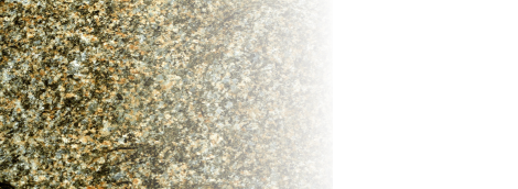
The underlying geology principally comprises metamorphic schists and gneises. At the Hill of Fare there is a boundary with a ‘Newer Calidonite’ granite. It is
at Craigton that granite was extracted for construction and there are still remnants of the quarry workings. Most of the area is covered by drift. Nearer the Dee
this comprises ribbons of sand deposits which track the edge of the valley up to a height of around 30 metres above the flood plain. These sand deposits
have been commercially worked in the past (near Milton of Crathes) and continue to be worked a Leith’s quarry near West Park. There is also evidence of
sand working at Loch of Park to the NE of Crathes.
Moving north from the Dee valley, the drift comprises glacial debris covering the shallow, undulating rock-head. This rock surface is overlain by a thin (less
than 50cm) rotted/decayed layer. In the extreme north-eastern corner there is an area of peat bog where peat was cut in the past.
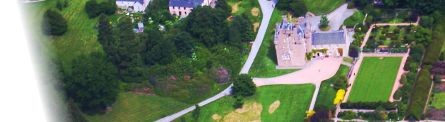
In various locations the bedrock comes to the surface, usually at the topographic summits. Especially so in the grounds of Crathes Castle to the NW of the
castle. Here the metamorphic rocks are massive, rounded outcrops often with extensive planar structures (Caroline’s Garden) or rounded ‘knobs’ with eroded
joint planes. Some of these exposures are surrounded by fragments of debris which have rolled away from the main exposure.
Flora:
Outwith the areas of arable farmland there is managed woodland, unmanaged woodland and scrub/marsh.
Almost all managed woodland is in the form of pine plantations consisting of larch, spruce and scots pine. This is harvested at around 40-50 years growth
with thinning at intermediate times. Around 2010 the planting of willow as a biomass fuel crop was undertaken on agricultural land. The chipped willow is used
to power the biomass energy centre in Banchory which will eventially supply a distributed heating network to around 200 homes as well as the proposed new
Banchory Sports Centre at Hill of Banchory.
Due to favourable grants and the need for cover for game birds, some limited planting of broadleaf species including oak, maple, beech and other indigenous
species has been undertaken in the last 20 years. The unmanaged woodland comprises birch, ash, sycamore, alder, oak, beech, rowan, cherry (geen), hazel
and mixed pines.
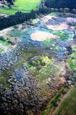
Wet areas around the Loch of Leys, Loch of Park and moorland to the north-east of Crathes are host to grasses, mosses, sedge, rushes and other wetland
species.
Fauna:
Birds found in the Crathes area: Blackbird, Bullfinch, Chaffinch, Crow, Cuckoo, Duck (Mallard), Fieldfare, Goldfinch, Goose (Greylag?), Greenfinch, Gull
(herring), House Martin, Jackdaw, Jay, Magpie, Moorhen, Owl, Raven, Redwing (rare), Robin, Rook, Sand Martin, Siskin, Skylark, Song Thrush, Sparrow,
Starling, Swallow, Tit, Tit - Blue, Tit - Great, Tree Creeper, Wagtail - Grey, Wagtail - White or Pied, Woodpecker (great spotted), Wood pigeon, Wren
Game birds: Pigeon, Duck, Goose, Pheasant (mostly reared), Quail, Partridge, Woodcock
Raptors: Buzzard (increasing over last 20 years), Kestrel, Merlin, Sparrow Hawk, Red Kite, Osprey (very rare)
Water and Sea-birds: Kingfisher, Heron, Seagull, Oyster Catcher, Curlew, Lapwing
Reptiles: Lizard, Frog, Toad, Newt, Slow-worm (rare)
Mammals: Rabbit, Hare, Weasel, Stoat, Hedgehog, Red Squirrel ( in decline), Grey Squirrel (recent arrival), Roe Deer, Badger, Fox, Field Mouse, House
Mouse, Rat, Otter, Shrew, Mole, Pine Marten
Fish: Minnows, Brown Trout, Sea Trout, Salmon and Eels.
Human occupation:
It is evident from archaeological finds that the area has been inhabited for over 10,000 years. At Birkwood on the south side of the Dee, Neolithic ‘pygmy
flints’ were discovered in the 1920s. These miniature flint tools showed a high level or working. It was often questioned why the items were so small and if
this was a reflection on the people who made the flint. The most probable answer is that flint was in short supply, the nearest natural occurrence being in the
Peterhead area where glacial scouring by southbound ice movement transported small flint nodules from an offshore Cretaceous submarine chalk outcrop
onshore and deposited it in moranic till deposits. Unlike the flint nodules of SE England, this Aberdeenshire flint was very small in size and hence the limit on
flint tool sizes.
Two significant archaeological sites have been excavated in the Crathes area. One is at Balbridie on the south side of the Dee, almost opposite Crathes
Castle. Here a large wooden structure was investigated. It was built using large vertical posts and is apparently one of the largest, earliest buildings to have
been discovered to date. It is thought to have been a communal dwelling dating from late neolithic or Bronze age times.
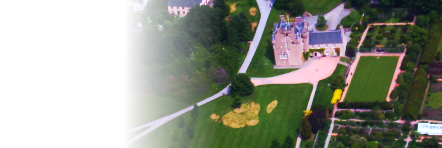
The other site is in the Warren Field at Crathes Castle on the right of the main entrance drive. Aerial photography of the area in the 1970s had shown a crop
growth anomaly and this location was eventually excavated around 2008. Again a wooden construction was identified along with numerous post-holes. In
2013 archaeologists published the news that the post-hole arrangement in the Warren Field was in fact the world’s oldest discovered solar/lunar calendar.
The post hole arrangement apparently aligned perfectly with astronomical features at different times of the year and was probably a method of determining
dates of religious festivals and crop planting. BBC Website
There are no known stone circles in the Crathes area although there are remains of at least two in Durris nearby and also at Garlogie.
The Romans had an encampment at Raedykes just south-west of Peterculter. It was one of a chain of such fortified encampments stretching up the east cost
of Scotland. Other nearby ones of a day’s march being at Rickarton west of Stonehaven and just south of Kintore. The Roman occupation in NE Scotland is
said to have lasted around 200 years. There is no known evidence of Roman remains in Crathes.
The arrival of St Colomba’s missionaries on Deeside in the 5th century was based in and around the current location of Banchory. And again, there is no
known evidence remaining in Crathes of this period
Prior to the 1300s few written records mention or pertain to Crathes. It would appear that the area was classified as the deer
forest of Drum. In 1326 the lands of Crathes were given to the Burnett of Leys family by King Robert the Bruce in recognition of
service and loyalty. The Burnetts have subsequently held unbroken title since that time. The lands and people of Crathes
became inseparably intertwined with the Burnett of Leys family.
In 2016, Alexander Burnett of Leys was elected as an MSP for Aberdeenshire West.
On the lands to the north of the village of Banchory, there lay a stretch of shallow water known as the Loch of Banchory or the
Loch of Leys. In the centre of the loch was a crannog (artificial island), which had been a place of refuge for centuries. For the
first 200 years of the Burnetts’ residence in the area, this crannog provided the site for the family’s principal stronghold. It is
likely that the crannog was enhanced and fortified. The loch is now drained and nothing remains but the island mound. The
crannog may be deserted but the memory of the Burnetts’ first home is kept alive in the traditional Scots territorial designation
of the head of the family as "Burnett of Leys".
The crannog provided the Burnetts with security and, since the family was not politically ambitious, life was peaceful on the
Loch of Leys. In 1560 Alexander Burnett and his wife Janet decided that a better home was needed for their family, and the
construction of Crathes Castle began. Initial building work took over 40 years and the castle was later extended and improved
over the years.
Few major or significant events took place over the coming centuries, the main one was the battle of Corriechie which took place just north of Hattonburn on
the slopes of the Hill of Fare in 1562. It was fought between the forces of George Gordon, 4th Earl of Huntly, chief of Clan Gordon against forces loyal to
Mary, Queen of Scots under James Stewart, 1st Earl of Moray. The Queen’s forces won the battle and a commemorative stone (erected in 1952) marks a
location not far from the site of the battle on the Raemoir to Aberdeen Road.
Crathes Farms:
The Ley
Drumfrennie
Hattonburn
Newmill - now farmed by the Cruickshank family
Myrebird
Minklets
Milton
Candieshill
Candygierlach
Todholes
Uppermills - now farmed by the Beaton family
Nethermills
Baldarroch
The Bush
Hirn
Doualty
Coy
Harestone - now farmed by the Barclay family
Rashenlochy
Kilduthie
Wicker Inn
About Crathes


UNDER
CONSTRUCTION


It was hoped to have found a description of the Crathes area in the
Statistical Account of Scotland. However, because of the more important
township of Banchory-Ternan nearby, Crathes has apparently not been
described in detail or isolation. The following is a collection of facts and
observations about Crathes.
Location and topography:
Crathes lies in the Dee valley some 18kms south-west of the city of
Aberdeen. Bounded by the River Dee to the south, the Hill of Fare to the
north, The Burn o’ Bennie at Banchory to the west and Drumoak to the
east, Crathes is an area of rural land comprising arable agriculture, forest,
peat bog and one principal settlement. Generally the topography rises
from the Dee in the south to the base of the Hill of Fare in the north,
affording the area a pleasant southerly aspect.
Climate:
Lying between the Grampian mountains and the sea, Crathes neither
suffers from the temperature extremes of the hills nor the wind and fog of
the coastal strip. Temperate would describe the climate. Average summer
temperature lies at around 12c and winter around 3c. Maximum summer
temperatures are around 20c and minimum winter temperatures -15c.
Snow can occur between November and March with up to 40cms in
extreme winters. Live daily weather reports and accurate weather records
going back a number of years can be found on-line here:
Geology:
The underlying geology principally comprises metamorphic schists and
gneises. At the Hill of Fare there is a boundary with a ‘Newer Calidonite’
granite. It is at Craigton that granite was extracted for construction and
there are still remnants of the quarry workings. Most of the area is
covered by drift. Nearer the Dee this comprises ribbons of sand deposits
which track the edge of the valley up to a height of around 30 metres
above the flood plain. These sand deposits have been commercially
worked in the past (near Milton of Crathes) and continue to be worked a
Leith’s quarry near West Park. There is also evidence of sand working at
Loch of Park to the NE of Crathes.
Moving north from the Dee valley, the drift comprises glacial debris
covering the shallow, undulating rock-head. This rock surface is overlain
by a thin (less than 50cm) rotted/decayed layer. In the extreme north-
eastern corner there is an area of peat bog where peat was cut in the
past.
In various locations the bedrock comes to the surface, usually at the
topographic summits. Especially so in the grounds of Crathes Castle to
the NW of the castle. Here the metamorphic rocks are massive, rounded
outcrops often with extensive planar structures (Caroline’s Garden) or
rounded ‘knobs’ with eroded joint planes. Some of these exposures are
surrounded by fragments of debris which have rolled away from the main
exposure.
Flora:
Outwith the areas of arable farmland there is managed woodland,
unmanaged woodland and scrub/marsh.
Almost all managed woodland is in the form of pine plantations consisting
of larch, spruce and scots pine. This is harvested at around 40-50 years
growth with thinning at intermediate times. Around 2010 the planting of
willow as a biomass fuel crop was undertaken on agricultural land. The
chipped willow is used to power the biomass energy centre in Banchory
which will eventially supply a distributed heating network to around 200
homes as well as the proposed new Banchory Sports Centre at Hill of
Banchory.
Due to favourable grants and the need for cover for game birds, some
limited planting of broadleaf species including oak, maple, beech and
other indigenous species has been undertaken in the last 20 years. The
unmanaged woodland comprises birch, ash, sycamore, alder, oak, beech,
rowan, cherry (geen), hazel and mixed pines.
Wet areas around the Loch of Leys, Loch of Park and moorland to the
north-east of Crathes are host to grasses, mosses, sedge, rushes and
other wetland species.
Fauna:
Birds found in the Crathes area: Blackbird, Bullfinch, Chaffinch, Crow,
Cuckoo, Duck (Mallard), Fieldfare, Goldfinch, Goose (Greylag?),
Greenfinch, Gull (herring), House Martin, Jackdaw, Jay, Magpie,
Moorhen, Owl, Raven, Redwing (rare), Robin, Rook, Sand Martin,
Siskin, Skylark, Song Thrush, Sparrow, Starling, Swallow, Tit, Tit - Blue,
Tit - Great, Tree Creeper, Wagtail - Grey, Wagtail - White or Pied,
Woodpecker (great spotted), Wood pigeon, Wren
Game birds: Pigeon, Duck, Goose, Pheasant (mostly reared), Quail,
Partridge, Woodcock
Raptors: Buzzard (increasing over last 20 years), Kestrel, Merlin, Sparrow
Hawk, Red Kite, Osprey (very rare)
Water and Sea-birds: Kingfisher, Heron, Seagull, Oyster Catcher, Curlew,
Lapwing
Reptiles: Lizard, Frog, Toad, Newt, Slow-worm (rare)
Mammals: Rabbit, Hare, Weasel, Stoat, Hedgehog, Red Squirrel ( in
decline), Grey Squirrel (recent arrival), Roe Deer, Badger, Fox, Field
Mouse, House Mouse, Rat, Otter, Shrew, Mole, Pine Marten
Fish: Minnows, Brown Trout, Sea Trout, Salmon and Eels.
Human occupation:
It is evident from archaeological finds that the area has been inhabited for
over 10,000 years. At Birkwood on the south side of the Dee, Neolithic
‘pygmy flints’ were discovered in the 1920s. These miniature flint tools
showed a high level or working. It was often questioned why the items
were so small and if this was a reflection on the people who made the
flint. The most probable answer is that flint was in short supply, the
nearest natural occurrence being in the Peterhead area where glacial
scouring by southbound ice movement transported small flint nodules
from an offshore Cretaceous submarine chalk outcrop onshore and
deposited it in moranic till deposits. Unlike the flint nodules of SE
England, this Aberdeenshire flint was very small in size and hence the
limit on flint tool sizes.
Two significant archaeological sites have been excavated in the Crathes
area. One is at Balbridie on the south side of the Dee, almost opposite
Crathes Castle. Here a large wooden structure was investigated. It was
built using large vertical posts and is apparently one of the largest,
earliest buildings to have been discovered to date. It is thought to have
been a communal dwelling dating from late neolithic or Bronze age times.
The other site is in the Warren Field at Crathes Castle on the right of the
main entrance drive. Aerial photography of the area in the 1970s had
shown a crop growth anomaly and this location was eventually excavated
around 2008. Again a wooden construction was identified along with
numerous post-holes. In 2013 archaeologists published the news that the
post-hole arrangement in the Warren Field was in fact the world’s oldest
discovered solar/lunar calendar. The post hole arrangement apparently
aligned perfectly with astronomical features at different times of the year
and was probably a method of determining dates of religious festivals and
crop planting. BBC Website
There are no known stone circles in the Crathes area although there are
remains of at least two in Durris nearby and also at Garlogie.
The Romans had an encampment at Raedykes just south-west of
Peterculter. It was one of a chain of such fortified encampments stretching
up the east cost of Scotland. Other nearby ones of a day’s march being at
Rickarton west of Stonehaven and just south of Kintore. The Roman
occupation in NE Scotland is said to have lasted around 200 years. There
is no known evidence of Roman remains in Crathes.
The arrival of St Colomba’s missionaries on Deeside in the 5th century
was based in and around the current location of Banchory. And again,
there is no known evidence remaining in Crathes of this period
Prior to the 1300s few written records mention
or pertain to Crathes. It would appear that the
area was classified as the deer forest of
Drum. In 1326 the lands of Crathes were
given to the Burnett of Leys family by King
Robert the Bruce in recognition of service and
loyalty. The Burnetts have subsequently held
unbroken title since that time. The lands and
people of Crathes became inseparably
intertwined with the Burnett of Leys family.
In 2016, Alexander Burnett of Leys was
elected as an MSP for Aberdeenshire West.
On the lands to the north of the village of
Banchory, there lay a stretch of shallow water
known as the Loch of Banchory or the Loch of
Leys. In the centre of the loch was a crannog
(artificial island), which had been a place of refuge for centuries. For the
first 200 years of the Burnetts’ residence in the area, this crannog
provided the site for the family’s principal stronghold. It is likely that the
crannog was enhanced and fortified. The loch is now drained and nothing
remains but the island mound. The crannog may be deserted but the
memory of the Burnetts’ first home is kept alive in the traditional Scots
territorial designation of the head of the family as "Burnett of Leys".
The crannog provided the Burnetts with security and, since the family was
not politically ambitious, life was peaceful on the Loch of Leys. In 1560
Alexander Burnett and his wife Janet decided that a better home was
needed for their family, and the construction of Crathes Castle began.
Initial building work took over 40 years and the castle was later extended
and improved over the years.
Few major or significant events took place over the coming centuries, the
main one was the battle of Corriechie which took place just north of
Hattonburn on the slopes of the Hill of Fare in 1562. It was fought
between the forces of George Gordon, 4th Earl of Huntly, chief of Clan
Gordon against forces loyal to Mary, Queen of Scots under James
Stewart, 1st Earl of Moray. The Queen’s forces won the battle and a
commemorative stone (erected in 1952) marks a location not far from the
site of the battle on the Raemoir to Aberdeen Road.
Crathes Farms:
The Ley
Drumfrennie
Hattonburn
Newmill - now farmed by the Cruickshank family
Myrebird
Minklets
Milton
Candieshill
Candygierlach
Todholes
Uppermills - now farmed by the Beaton family
Nethermills
Baldarroch
The Bush
Hirn
Doualty
Coy
Harestone - now farmed by the Barclay family
Rashenlochy
Kilduthie
Wicker Inn
About Crathes


A small, rural community on Royal Deeside